A river runs under it
Each of city's historic bridges has unique story
Advertisement
Read this article for free:
or
Already have an account? Log in here »
To continue reading, please subscribe:

Digital Subscription
One year of digital access for only $205*
- Enjoy unlimited reading on winnipegfreepress.com
- Read the E-Edition, our digital replica newspaper
- Access News Break, our award-winning app
- Play interactive puzzles
*First annual payment billed as $205.00 + GST for one year. This annual subscription will automatically renew at $233.00 + GST every 52 weeks (10% off the regular annual price of $259.35). Offer available to new and qualified returning subscribers only. Cancel any time.
To continue reading, please subscribe:
Add Free Press access to your Brandon Sun subscription for only an additional
$1 for the first 4 weeks*
- Enjoy unlimited reading on winnipegfreepress.com
- Read the E-Edition, our digital replica newspaper
- Access News Break, our award-winning app
- Play interactive puzzles
*Your next Brandon Sun subscription payment will increase by $1.00 and you will be charged $17.95 plus GST for four weeks. After four weeks, your payment will increase to $24.95 plus GST every four weeks.
Read unlimited articles for free today:
or
Already have an account? Log in here »
Hey there, time traveller!
This article was published 06/09/2020 (2140 days ago), so information in it may no longer be current.
They span the muddy waters from which Winnipeg derives its name. They connect neighbourhood to neighbourhood. They’re a fundamental feature of our city.
Winnipeg has a reputation as a “River City,” but many don’t know the stories behind the bridges they use every day.
While a bridge may seem to be a boring piece of basic infrastructure, many of Winnipeg’s have fascinating histories that go back more than 100 years.
Norwood Bridge
The gateway to the heart of the city, the current Norwood Bridge is actually the third to exist in the location just south of the Red and Assiniboine’s confluence at The Forks.
The most well-known and photographed feature of the Norwood Bridge is the River Arch, which stands proudly between the two spans and looms over the area as a 15-metre-tall sentinel.

The River Arch was designed by Pittsburgh-born artist Catherine Widgery and “reflects the dynamic, modern Winnipeg in harmony with its past traditions and the natural world,” explains the CCCA Canadian Art Database.
It’s a Prairie-inspired piece, through and through: the pair of concrete columns have bison bases and the torches that the arch cuts through are topped with gold-leafed wheat sheaves. The pixelated scene on the arch itself is taken from a photo of a harvested field.
There was a Norwood Bridge for more than 100 years before the Arch’s installation in 1999, however. Frugal Winnipeggers would bristle at the thought of paying a toll to enter or exit downtown, but that’s just what folks had to do to cross its first incarnation.
Privately constructed by the Norwood Improvement Co. and Norwood Bridge Co., it was built as part of a suburb erected on 400 acres of land the companies purchased in the Town of St. Boniface, says a Jan. 20, 1891, edition of the Manitoba Daily Free Press.
The Town of St. Boniface purchased the bridge in 1904 and made it free to cross in 1909. A low bridge, it was often rocked by ice floes during spring floods. Take for example the harrowing scene described in the Manitoba Free Press on April 25, 1905.
“On Saturday night some spectators, who had crowded onto one of the bridges, had a narrow escape from serious injury. A huge floe was coming down on the surface of the stream, and when under the bridge collided with another large piece of ice… this brought the jagged apex into violent collision with the planking of the bridge. Half a dozen planks were driven upwards, and the serrated ice projected some feet over the wooden flooring.” That caused a mass exodus of rubberneckers.
In August 1929, the bridge was receiving heavier traffic than it could handle and was deemed unsafe, with streetcar service over it discontinued. In 1931 — as the Great Depression was just beginning — construction began on a brand new Norwood Bridge, built by the Dominion Bridge Co. as part of a government unemployment relief project.
By September 1931, construction was nearing completion, and a Manitoba Free Press insert waxed poetic about the new steel span’s beauty: the “splendid width of roadway,” the “graceful curve,” its “ample underclearance,” and its “quiet but dignified appearance.”
It opened in early November of the same year at a final price of $590,000, and stood until it was replaced by the current Norwood Bridge, which came in at $116 million and officially opened on Oct. 19, 1999.
Like many projects, the newest Norwood Bridge was over budget by $13 million and motorists complained about the traffic tie-ups construction caused. Even the River Arch, now well-liked and well-photographed, received a scathing review from art reviewer Scott Barham.
“We all will be haunted by River Arch with a persistence which will make broken bones seem like mere pinpricks,” he wrote in the Free Press, calling it a “piece of Steamboat Willie Boosterism” and “an example of low-ball public art where the artist, hence the art is removed from the piece.”
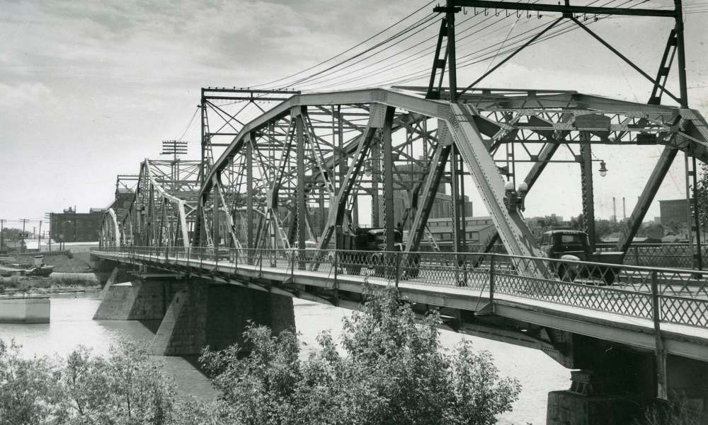
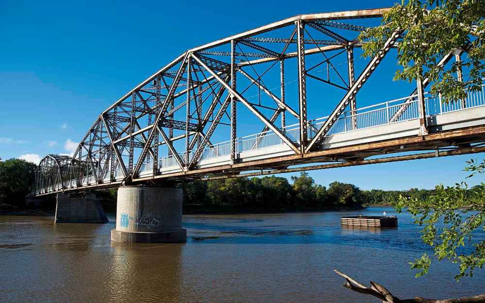
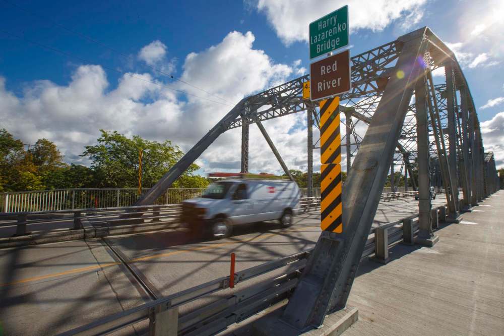
Harry Lazarenko Bridge (Redwood Bridge)
Spanning the Red River and connecting William Whyte to Elmwood, the Harry Lazarenko Bridge — formerly and perhaps still better known as the Redwood Bridge — is the bridge that’s been continuously open to traffic the longest, at 111 years straight.
The early 1900s was a different time in the construction industry, it seemed. City engineer Henry Ruttan didn’t bother getting approval from the Federal Minister of Marine before work on the truss bridge began in January 1907, nor did the plan for the bridge take seasonal ice floes or river traffic into account, according to the Manitoba Historical Society.
The world was different but people were the same: some complained. Two months after construction got underway, ship owners who used the Red as a commercial waterway submitted a petition demanding work stop immediately, as they were concerned the 73-foot distance between central piers was too narrow to navigate.
But the bridge was a necessity — Elmwood had joined the City of Winnipeg in 1906, land sales in the area were booming and the residents wanted easy access to Main Street. So plans were revamped to include 27 more feet between piers, and work continued.
Construction was slowed yet again by a wage dispute — the workers were upset they were getting paid between 15-and-a-half and 17 cents per hour instead of the 20 cents outlined in their fair wage clause — but eventually, the bridge was completed. It used 740 tons of steel in all and opened on Jan. 12, 1909.
The Redwood Bridge remained the Redwood Bridge for 102 years before it was renamed the Harry Lazarenko Bridge in October 2014, in honour of the city councillor who served the Mynarski Ward from 1973-77 and 1983-2010.
Elm Park Bridge
Believe it or not, the Elm Park Bridge wasn’t built so people could amble across the river on warm summer evenings while enjoying creamy concoctions from the Bridge Drive-In.
The bridge has become iconic as the backdrop for aesthetic photos of people posed with Peach Velvets and Googs. But back in the early 1900s, R.F. McWilliams just wanted a bridge to boost land values.
McWilliams owned Elm Park, which was where Kingston Row and Kingston Crescent are. Like any developer worth his salt, McWilliams wanted to make his land as attractive as possible to buyers, and that included a bridge better than the pontoon bridge that provided access to Elm Park — and the dance hall, merry-go-round, roller coaster, and other attractions it held — since 1891.
The Elm Park Co. “for many years had tried to get the city to co-operate with it in building a bridge across the Red River, but without success,” a Free Press piece from November 1912 notes. So McWilliams decided to build one of his own. The RM of St. Vital council tried to get it built closer to Pembina Street, now Pembina Highway — and even made a recommendation in December 1912 that it be moved — but McWilliams’ plans ultimately won out.
The steel truss span opened to traffic in 1914 and collected tolls to offset the $125,000 it cost to construct: five cents for pedestrians, 10 cents for cars, and 25 cents for trucks.
Perhaps if the Elm Park Co. spent a bit more, it could have made its bridge a little bit wider. The deck was only 16 feet wide and barely managed to accommodate the oversized autos of the 1940s and ’50s. As Brad Neirick, a city of Winnipeg bridge engineer, said in 2010: “most vehicles were about eight feet wide, so it was probably just wide enough for two cars to pass, but you’d probably take each other’s’ mirrors off as you were passing each other.”
In November 1945, the municipality of St. Vital purchased the bridge for $5,000, with the City of Winnipeg chipping in one-third of that and promising to cover one-third of ongoing maintenance costs. Did it ever need maintenance: in August of the same year, it was closed to all vehicular traffic “as a result of the unsafe driveway,” with the Elm Park Co. unable to say when or whether it’d be repaired and reopened.
In 1946, the new owners spent $12,000 on a much-needed repair job and eliminated the toll. It remained free to cross until it was closed to vehicular traffic in 1974. The BDI, meanwhile, established its spot on Jubilee in 1957.
In the mid 1990s, the BDI was in danger of losing the bridge it had named the ice cream shop after.
In the spring of 1996, the Free Press reported that the bridge could collapse if high water and ice from spring flooding overturned the eroding concrete piers. The city played with the idea of tearing it down but decided not to after learning it would cost a million dollars.
Instead, the city invested $300,000 to fix the piers in 2010, leaving it open as an active transportation option and for BDI customers to enjoy as an accoutrement to their sweet treats. The city celebrated the bridge’s 100th birthday in 2014, and of course, free ice cream was part of the festivities.
Louise Bridge
Without the Louise Bridge, Winnipeg might not be the city of 700,000 plus it is today.
With much talk in recent years of relocating rail lines and railyards outside city limits, it’s tough to imagine an era where a city actually wanted to attract rail development, but that’s just what the Louise Bridge — named after Queen Victoria’s daughter Princess Louise, Duchess of Argyll — was designed to do.
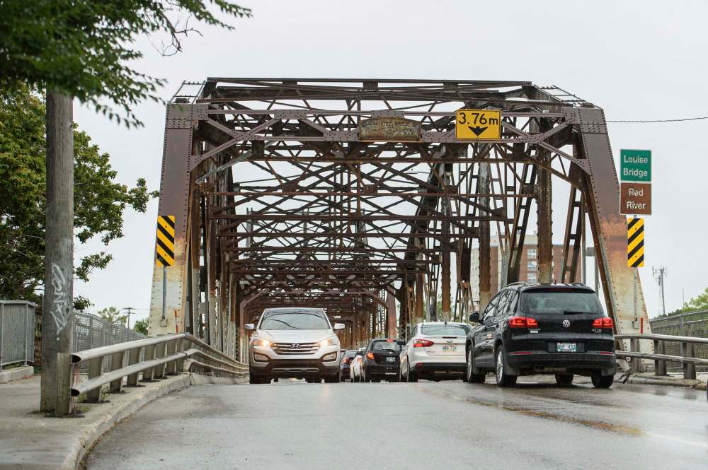
Built in 1881, the bridge spanning the Red in Point Douglas was a come-on for the Canadian Pacific Railway, which was laying tracks for Canada’s first transcontinental railway from sea to shining sea.
Mayor Alexander Logan led this initiative to get the CPR to abandon their plan to cross the Red in Selkirk. Not only did city council pay $300,000 for the bridge’s construction, it also offered the CPR $200,000, land to build a railway station, and tax exemptions.
While the reporter didn’t find any record of Winnipeggers being against spending on such a project, he did find some letters to the editor in the Aug. 11, 1880, edition of the Free Press, taking umbrage with the groundbreaking ceremony that went off the rails. It seems the crowds imbibed liquor meant for city councillors and became drunk and disorderly:
“I was astonished to see a place fitted up like a bar-room from which were freely dispensed for every one, young and old, free, intoxicating liquors,” one citizen wrote.
‘A. Ratepayer’ expressed a similar sentiment the same day. “Did you act honestly and in the best interest of citizens when you (City Council) voted to spend five hundred dollars of the people’s money in providing intoxicating liquors on the auspicious occasion of the laying of the corner stone of the Louise Bridge?” they wrote.
“I trust, gentlemen, that if you will not resign, as suggested, you will at least rise and explain to an outraged community the reasons which indeed you so betray the trust reposed to you by your fellow citizens, and show good reasons for squandering the money of a city already overburdened with debt?” he continued.
Back to the bridge, whether it was a bribe to the railway or an investment in Winnipeg’s future is subjective. Regardless, it might have been the best money spent in the city’s history.
The bridge, which did dual duty as a rail and traffic span, finally linked eastern and western Canada by rail. Thanks to its central location, Winnipeg became an important transportation hub and a massive influx of immigrants seeking employment arrived in the years to follow. Winnipeg’s population was just 7,900 when the bridge was built, but by 1921, it was 179,000.
An October 1881 notice in the Manitoba Free Press reported that in the prior year, 251 single buggies, 168 single wagons, 43 double buggies, 105 single horses, and 108 cattle made the crossing — until 1904, when the CNR discontinued use. In 1911, it was rebuilt.
The city’s 2011 transportation master plan called for the Louise Bridge to be replaced with a brand-new four-lane structure by 2016, but that didn’t come to pass as it was leapfrogged by other large-scale projects. Eighty-one years after its namesake died, the two-lane bridge lives on.