

For the love of the lake… any lake
Manitoba artist-craftsman-cartographer Kevin Morissette creates detailed, three-dimensional depth-relief maps for clients' to enjoy when they're not in or on their favourite bodies of water
Advertisement
Read this article for free:
or
Already have an account? Log in here »
To continue reading, please subscribe:
Monthly Digital Subscription
$0 for the first 4 weeks*
- Enjoy unlimited reading on winnipegfreepress.com
- Read the E-Edition, our digital replica newspaper
- Access News Break, our award-winning app
- Play interactive puzzles
*No charge for 4 weeks then price increases to the regular rate of $19.95 plus GST every four weeks. Offer available to new and qualified returning subscribers only. Cancel any time.
Monthly Digital Subscription
$4.99/week*
- Enjoy unlimited reading on winnipegfreepress.com
- Read the E-Edition, our digital replica newspaper
- Access News Break, our award-winning app
- Play interactive puzzles
*Billed as $19.95 plus GST every four weeks. Cancel any time.
To continue reading, please subscribe:
Add Free Press access to your Brandon Sun subscription for only an additional
$1 for the first 4 weeks*
*Your next subscription payment will increase by $1.00 and you will be charged $16.99 plus GST for four weeks. After four weeks, your payment will increase to $23.99 plus GST every four weeks.
Read unlimited articles for free today:
or
Already have an account? Log in here »
Hey there, time traveller!
This article was published 30/10/2021 (1531 days ago), so information in it may no longer be current.
The majority of Manitobans, landlubbers included, are fully aware that the largest lake in the province is Lake Winnipeg, and that the deepest, courtesy of a meteor strike some 20 million years ago, is West Hawk Lake, in the Whiteshell.
But how many know that the clearest is the aptly named Clearwater Lake, near The Pas, where the bottom is visible up to 11 metres? Or that the one with the longest tag is — too bad we don’t get paid by the letter — northern Manitoba’s Pekwachnamaykoskwaskwaypinwanik Lake, Cree for “where the wild trout are caught by fishing with hooks.”
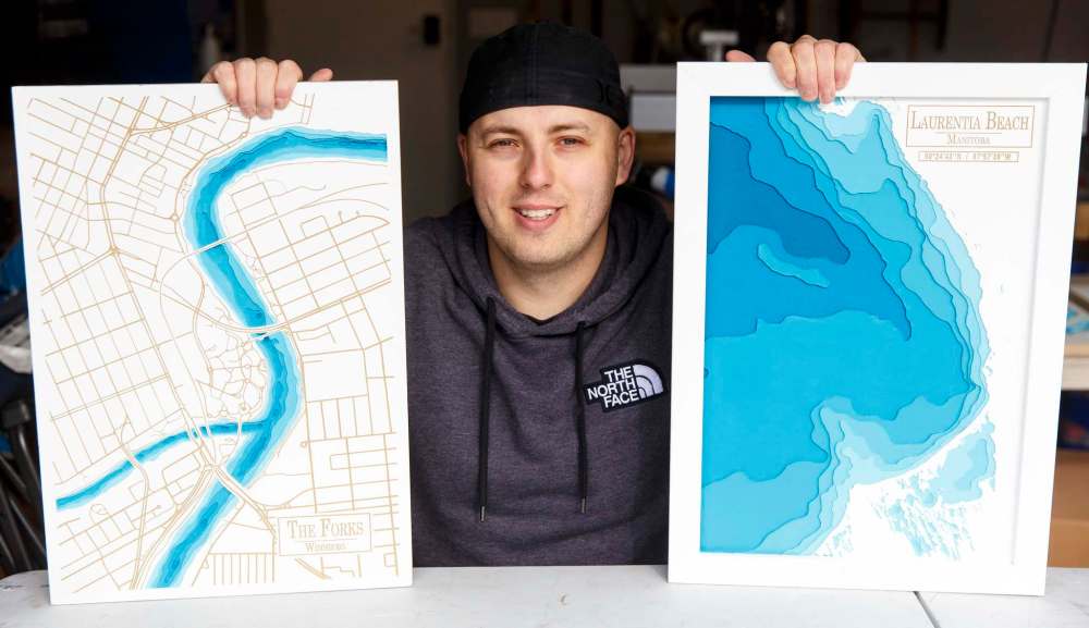
That’s where Kevin Morissette, founder of Lake Depth Maps by KM, a venture that turns out meticulously crafted, three-dimensional replicas of people’s favourite bodies of water, enters the picture.
Since founding his aqua-charged biz, the 31-year-old has twigged into random facts about scores of lakes he wasn’t previously familiar with; not just in Manitoba and northwestern Ontario but in other parts of the world, as well.
“My high school buddy’s wife is from the Philippines and a while back he asked if I could make them a map of Taal Lake, which turned out to be this crazy-looking lake that was formed inside a volcano,” he says, standing in his brother’s insulated double garage, half of which serves as his year-round workspace. “I haven’t been able to find an accurate depth chart for it yet, but when I do it’ll be a fun one to throw together.”
It sounds funny to hear but Morissette stops short of describing himself as a “lake guy.” Sure, he used to hop in with pals headed to the beach every now and again, but because his family didn’t own a cottage or rent at the same spot every summer, there has never been one lake he’s regarded as “his.” He did visit Clear Lake semi-regularly with another friend, mind you, so ahead of Christmas 2019, he decided to make her a raised-relief map of the area, based on similar maps he’d spotted online. (”No,” he says with a shrug, when asked if he had any cartography skills going in; it was just something he was confident he could do, being comfortable around tools and such.)
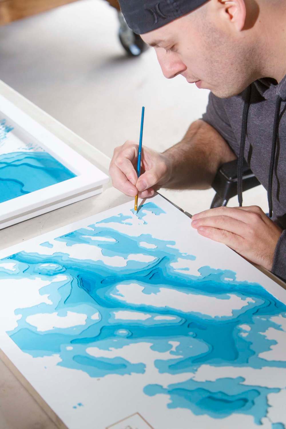
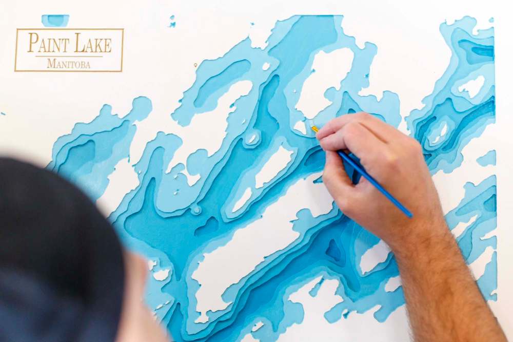
It proved to be an arduous undertaking. First, he traced a projected outline of the lake onto a thick square of Styrofoam, using a satellite image he found on Google Maps. Then, utilizing different sport-fishing websites that detail how deep or shallow a certain lake is and where the drop-off points and channels are, he carefully mirrored those features by carving out the various contours with a razor-sharp, surgical scalpel.
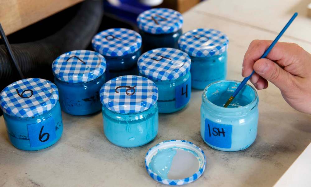
Sheets of heavy-duty, card stock paper served as subsequent layers, 11 in total, each expertly cut and affixed to the Styrofoam base with an industrial-strength adhesive. Painting followed, a dark hue of blue for the most cavernous portion of the lake, a bit lighter as he worked his way up.
Did his friend recognize what she was staring at, when she unwrapped her present? You bet, he says, adding she couldn’t believe he’d gone to all that trouble, close to 40 hours worth when all was said and done.
In February 2020, once the recipient had shown her gift off to friends and family, a number of them began reaching out to Morissette, wondering if he could do something comparable in regards to a lake or beachscape they held dear. He was happy to oblige. Twenty-five lake depth maps later, by which time the ring finger of his right hand was sporting a painful, bulbous callus caused by gripping his cutting utensil too tightly for days on end, he thought to himself, OK, there has to be a better method.
“It’s not like I wasn’t satisfied with the look of what I was doing; I was,” he explains, holding up a map done the “old way,” a reproduction of Lake Metigoche, which straddles the Manitoba-North Dakota border. “It’s just that they felt a little too… crafty, and I was of the opinion people looking for a higher-end product might not be 100 per cent satisfied.”
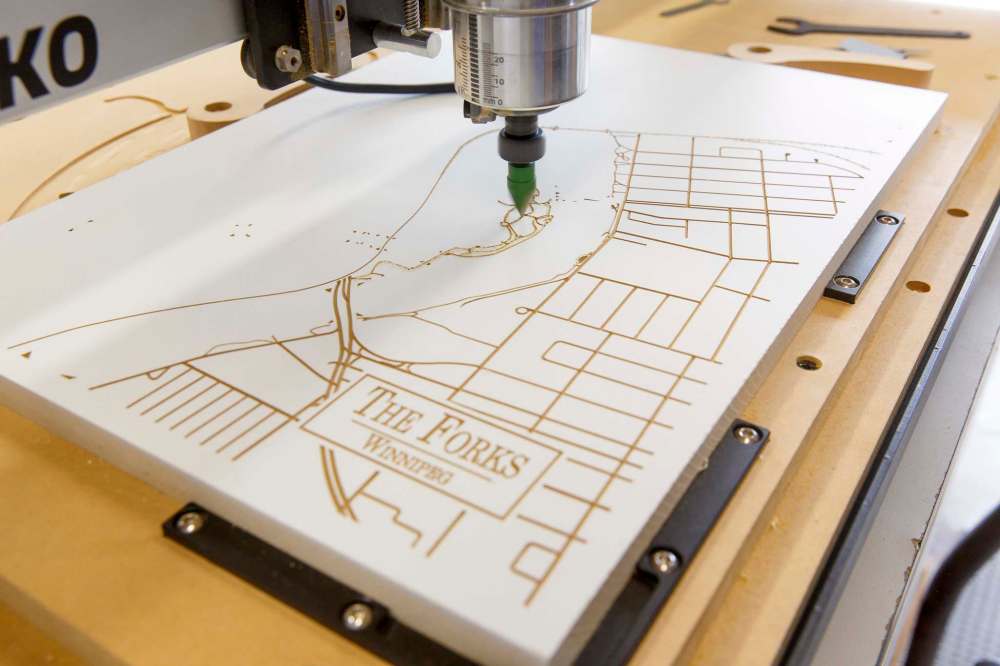
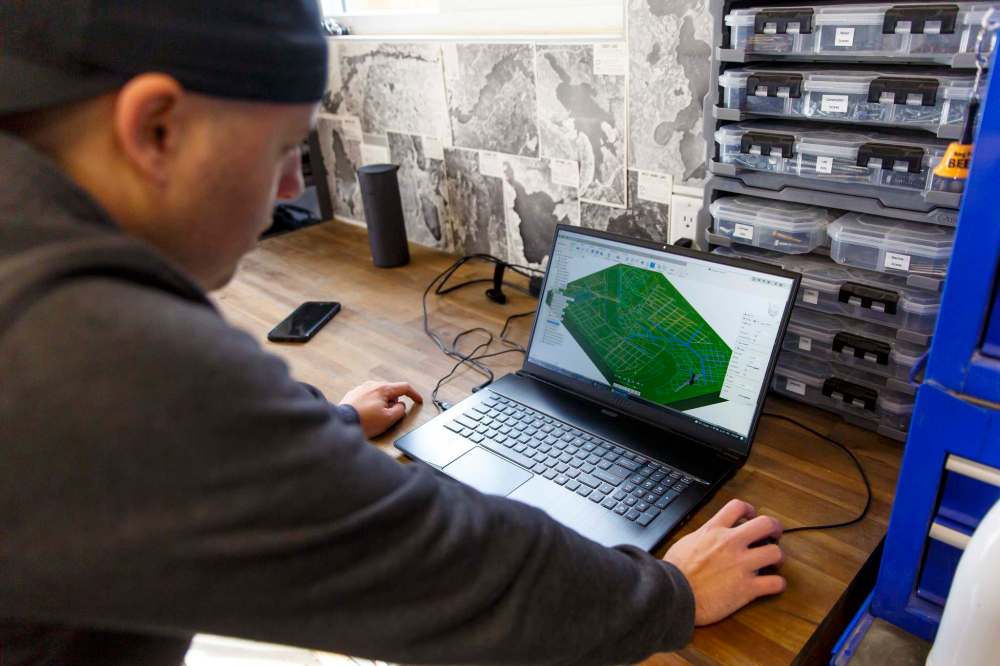
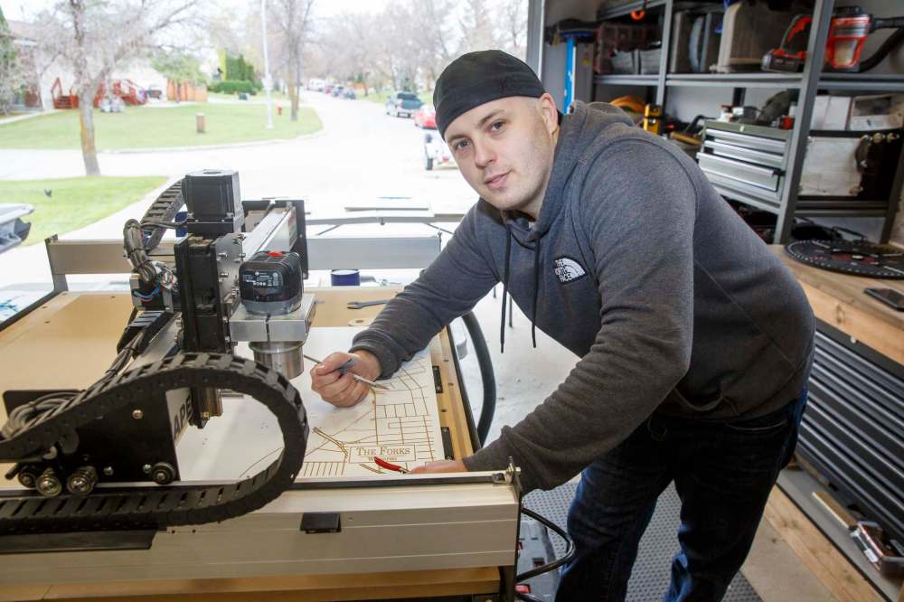
He did his homework and around this time last year he invested in a computer numerical control (CNC) machine, an automated device that makes complex, precision cuts into wood or other material based on a pre-programmed set of instructions. He spent the next eight months teaching himself how to use the routing contraption and its assorted programs, having replaced the Styrofoam with medium-density fibreboard.
Satisfied he knew what he was doing, he officially launched Lake Depth Maps by KM in July, and began accepting custom orders through his website, www.lakedepthmaps.com.
One of the first messages he received was from a person living in California who was hoping to land a depth map of Lake Tahoe. Morissette replied he was sorry, but he hadn’t figured out shipping to the States just yet. That’s when the gent offered to pay him US$700, more than three times what he charges for a single specimen. Err, what was that address again, he asked?
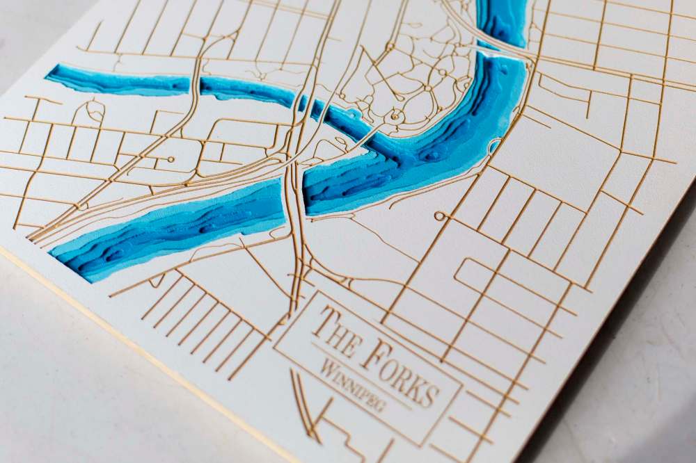
To date, Morissette has accepted only commissioned jobs, storing the mapping files he creates in a pair of laptops so if another person from, say, Traverse Bay or Falcon Lake gets in touch, he’ll have a bit of a head start. With an eye toward the retail market, he may deviate from that approach in the not-too-distant future, especially when it comes to maps he feels carry a broader appeal, like one he put the finishing touches on last week, a pullback view of the Red and Assiniboine rivers, showing where they meet at The Forks.
“It’s also the first one I’ve done where I’ve added streets and roads,” he says, laughing when a scribe points out that the Red isn’t exactly the attractive shade of azure he selected. “I know what you mean, but I’m fairly certain if I went with the murky, brown colour it actually is, it wouldn’t have been as visually appealing.”
The thing Morissette enjoys most when customers see the end product for the first time is how, almost to a person, they begin running their fingers over its assorted curves, telling him this was where they learned to swim, or that’s where they hooked a big one.

“Once somebody called what I do physical-touch art and I thought, yeah, that’s an excellent way of putting it,” he says, adding he’s been toying with the notion of programming his CNC machine to write place names in braille, so that people who are visually impaired can read the name of the lake-in-question and its co-ordinates, in addition to feeling its bumps and contours.
Before we go, a word of caution if you ever invite Morissette over to play cards or watch the game: it’s highly likely he’ll be running late.
“There’ve been occasions when I was supposed to have been at a friend’s for dinner at six or seven when I looked up at the clock and gone, ‘Holy cow, it’s 9:30!” he says, agreeing that living in a province with an estimated 100,000 lakes means he shouldn’t be running out of ideas any time soon.
“Usually when I’m mapping out a lake I’ve never done before, I’m so excited to see how it’s going to turn out that I’m in my own world, pretty much; just me, my tools and whatever music or podcast I have on in the background. It isn’t hard to get lost in my work, it really isn’t.”
david.sanderson@freepress.mb.ca
Dave Sanderson was born in Regina but please, don’t hold that against him.
Our newsroom depends on a growing audience of readers to power our journalism. If you are not a paid reader, please consider becoming a subscriber.
Our newsroom depends on its audience of readers to power our journalism. Thank you for your support.
Related Articles
Warm and fuzzy for Winnipeg winter


Advertisement Advertise With Us
Advertisement Advertise With Us