


Slow movement at City Hall

Advertisement
There is no denying that Winnipeg’s active transportation infrastructure has improved over the past few years, but connectivity between neighbourhoods is a slow work in progress preventing it from reaching its full potential.
Case in point: South Osborne.
It has a network of paths and trails that is among the most developed in the city. The network isn’t perfect — there are no dedicated bike lanes on Osborne itself — but it works well enough that anywhere in the community is safely accessible by bicycle.
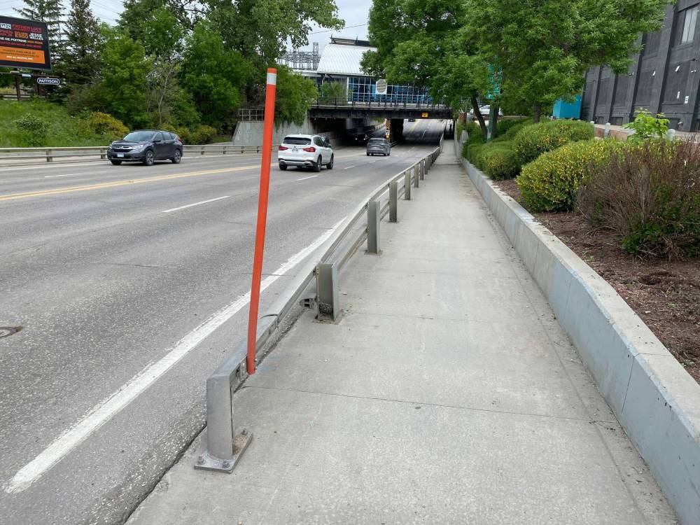
Photo by
The sidewalks and roadway that go beneath the Osborne Street underpass are not wide enough to safely accommodate cyclists.
But South Osborne is geographically isolated from its surroundings. It is almost entirely surrounded by the Red River on three sides, and on the other by the rail yards and rapid transit line.
The St. Vital Bridge has recently been re-surfaced and widened, and dedicated bike paths down Jubilee have helped connect the neighbourhood both to the south, and to Pembina.
Where the problem lies is to the north — towards Osborne Village and downtown. There, cyclists are left with two options: brave the treacherous and unsafe bottleneck created by the underpass, or take a detour behind the South Osborne Xchange building, down a gravel path, and all the way around to exit on the Norwood Bridge.
The detour isn’t a terrible option for someone on a leisurely weekend bike ride, but for would be commuters — the people who would like to use the active transportation network for transportation — it adds nearly two kilometres to what would otherwise be a direct commute downtown.
The alternative, though, is worse.
The sidewalks and roadway that go beneath the underpass are not wide enough to safely accommodate cyclists. They are also slanted and often sandy, reducing traction, and increasing the danger especially to pedestrians, but also to drivers, and to the cyclists themselves.
Crime statistics have already given Winnipeg an unfavourable reputation — a fact that is reflected in the city’s budget — but statistics show Winnipeg’s roadways are just as much reason for concern.
Among Canadian cities, Winnipeg ranked first in Canada for traffic deaths per 100,000 residents in 2025.
Roadway fatalities nearly matched homicides, and the number of people who reported being victims of collisions nearly doubled those who reported being victims of violent crimes. Of the victims of collisions, 156 were pedestrians, and 130 were cyclists.
When the Osborne Street CN Rail underpass was converted into a bus station back in 2009, the construction of a busway bridge over Osborne Street, of a tunnel below CN’s Fort Rouge Yards, and the purchase of 11 pieces of private property accounted for a large portion of Phase One’s $138-million price tag.
There was nothing left over for the proposal to widen the underpass itself.
But construction projects on Roblin Boulevard, Hargrave Street, Day Street, and University Crescent were also intended to move Winnipeg’s active transportation agenda forward.
Each one was planned and paid for. All went uncompleted.
There is a line item in the city’s Interactive Infrastructure Plan for roads-regional called “underpass AT improvements,” with spending planned for 2029.
Assuming it goes through, it will only have taken 20 years.
Andrew Braga
South Osborne community correspondent
Andrew Braga is a community correspondent for South Osborne.
Our newsroom depends on a growing audience of readers to power our journalism. If you are not a paid reader, please consider becoming a subscriber.
Our newsroom depends on its audience of readers to power our journalism. Thank you for your support.
Andrew Braga
South Osborne community correspondent
Andrew Braga is a community correspondent for South Osborne.
Our newsroom depends on a growing audience of readers to power our journalism. If you are not a paid reader, please consider becoming a subscriber.
Our newsroom depends on its audience of readers to power our journalism. Thank you for your support.
Advertisement Advertise With Us